


Barnett II Voting District, Morgan County, Missouri
About
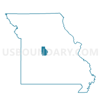
Outline

Summary
| Unique Area Identifier | 609187 |
| Name | Barnett II Voting District |
| County | Morgan County |
| State | Missouri |
| Area (square miles) | 23.44 |
| Land Area (square miles) | 23.43 |
| Water Area (square miles) | 0.01 |
| % of Land Area | 99.97 |
| % of Water Area | 0.03 |
| Latitude of the Internal Point | 38.37028090 |
| Longtitude of the Internal Point | -92.71775380 |
Maps


Graphs
Select a template below for downloading or customizing gragh for Barnett II Voting District, Morgan County, Missouri


Neighbors
Neighoring Voting District (by Name) Neighboring Voting District on the Map
- Barnett I Voting District, Morgan County, MO
- Eldon Rural Voting District, Miller County, MO
- Gravois Mills Voting District, Morgan County, MO
- Indian Creek Voting District, Morgan County, MO
- Rocky Mount Voting District, Miller County, MO
- Versailles Voting District, Morgan County, MO
Top 10 Neighboring County Subdivision (by Population) Neighboring County Subdivision on the Map
- Saline township, Miller County, MO (8,315)
- Osage township, Morgan County, MO (6,175)
- Moreau township, Morgan County, MO (5,854)
- Franklin township, Miller County, MO (2,641)
Top 10 Neighboring Place (by Population) Neighboring Place on the Map
Top 10 Neighboring Unified School District (by Population) Neighboring Unified School District on the Map
Top 10 Neighboring State Legislative District Lower Chamber (by Population) Neighboring State Legislative District Lower Chamber on the Map
Top 10 Neighboring State Legislative District Upper Chamber (by Population) Neighboring State Legislative District Upper Chamber on the Map
Top 10 Neighboring 111th Congressional District (by Population) Neighboring 111th Congressional District on the Map
Top 10 Neighboring Census Tract (by Population) Neighboring Census Tract on the Map
- Census Tract 4701, Morgan County, MO (6,046)
- Census Tract 9627, Miller County, MO (4,357)
- Census Tract 9626, Miller County, MO (3,581)